La Niña to Bring More Snowfall to Many this Winter
La Niña is back — and it could make this winter colder, snowier, and stormier across much of the U.S. HailTrace Meteorologist Mikayla Smith breaks down what to expect and how to stay ahead with real-time storm tracking and alerts from HailTrace.

The Climate Prediction Center (CPC) announced that La Niña conditions have officially been detected and should stick around through December, if not into early 2026.
This La Niña is forecast to remain weak, but it could still bring impacts to the 2025-2026 Winter Season.
Fore roofers and restoration professionals, that means shifts in where and when severe weather might strike - and fresh opportunities to get ahead using tools like HailTrace.
What is La Niña?
According to NOAA's National Ocean Service -
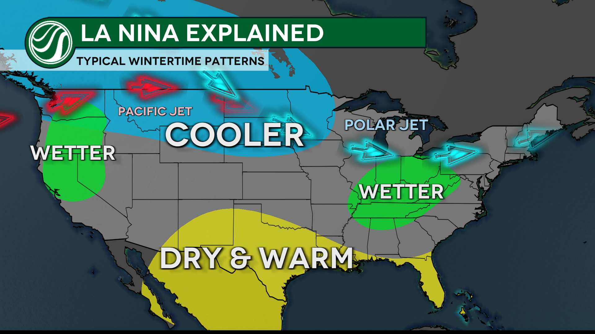
During La Niña events, trade winds are even stronger than usual, pushing more warm water toward Asia. Off the west coast of the Americas, upwelling increases, bringing cold, nutrient-rich water to the surface. These cold waters in the Pacific push the jet stream northward. This tends to lead to drought in the southern U.S. and heavy rains and flooding in the Pacific Northwest and Canada. During a La Niña year, winter temperatures are warmer than normal in the South and cooler than normal in the North. La Niña can also lead to a more severe hurricane season.
In short, La Niña shifts the jet stream - bringing in more cold and snow up north, drier conditions in the south and the potential for more extreme weather overall.
This transition from a neutral phase to La Niña could even bring impacts to the tail end of the 2025 Atlantic Hurricane Season.
One could say it already has. Since the announcement of the La Niña being present, the Atlantic Basin has had Major Hurricane Melissa. A category 5 monster hurricane that made landfall in Jamaica on October 28th, 2025, tied for the strongest hurricane in history at landfall. It was the 4th major hurricane of the 2025 Atlantic Hurricane Season, which had been under average statistically, to this point.
November storms could have the greatest impacts due to the switch to a La Niña weather pattern. There is less wind shear in the regions of the Atlantic basin where tropical weather develops, which could increase the odds for a more active end to hurricane season.
Hurricane season officially ends on November 30th.
La Niña Winter Impacts - What History Tells Us
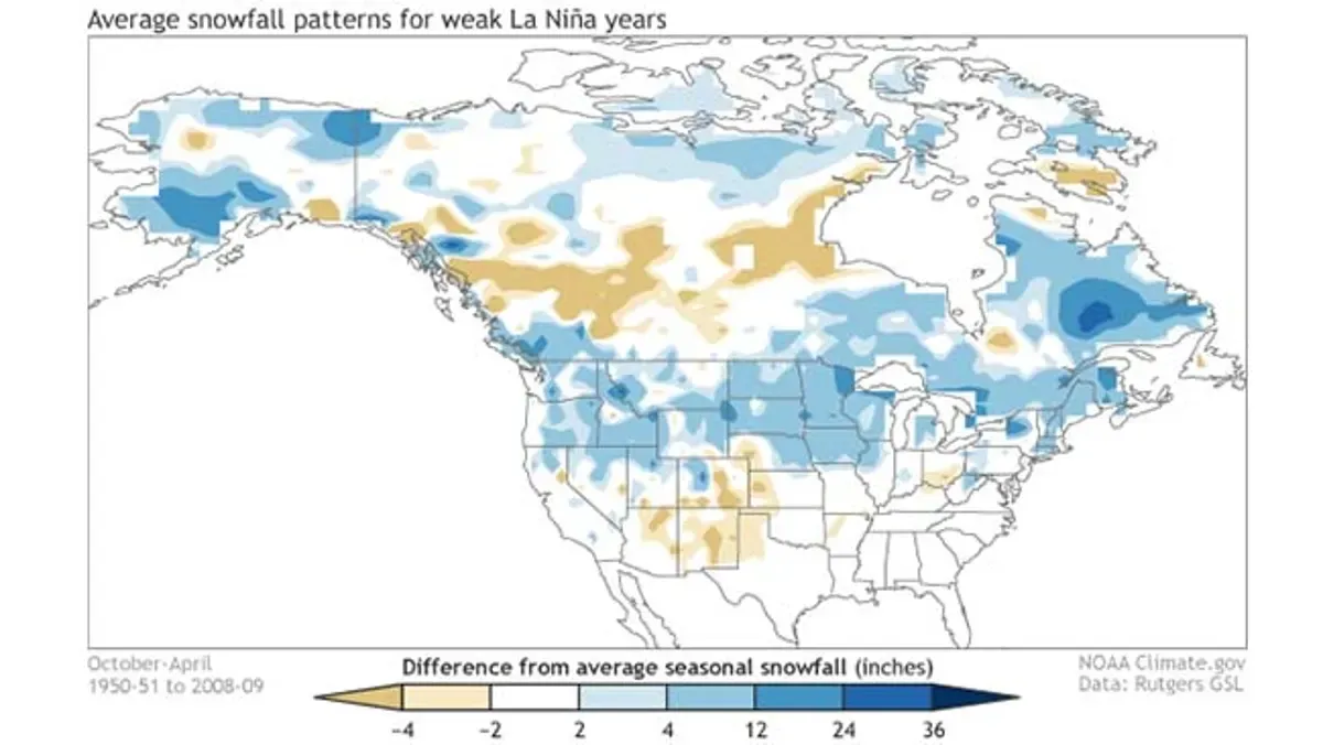
The CPC examined snowfall during weaker La Niña years from 1950-2009 and found a pattern that supports more snowfall for many in the U.S!
Generally, weak La Niñas will produce above-average snow across much of the northern portion of the U.S. This extends from the Pacific Northwest, across the Canada border, leading to the New England region.
Another correlation is that the desert Southwest tends to experience less snowfall, especially in the southern parts of the Rockies! Also, near the Ohio Valley trends favor below-average snowfall in historical records.
Areas shaded in white are considered more neutral, where the study did not find enough evidence present to strongly suggest snowfall patterns one way or another.
With the previous study concluding in 2009, scientists wanted an updated picture of how more recent winters were being impacted by La Niñas.
The CPC once again examined snowfall during weaker La Niña years, but this time set the range from 1991-2020.
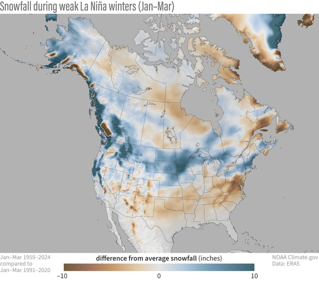
Similar to the first study done, weak La Niñas produce above-average snow across much of the northern portion of the U.S. This extends from the Pacific Northwest to the New England region. What was notably different in this newest study was a trend for heavier snowfall in Michigan and the High Plains.
Different from the original study, there is much fewer white, or neutral conditions for the southern portion of the U.S. Most weaker La Niñas provide less than average snowfall in the south, which is clear in the 1991-2020 map.
For you roofing and restoration guys, that northern snow trend often means more ice damming and roof lead claims.
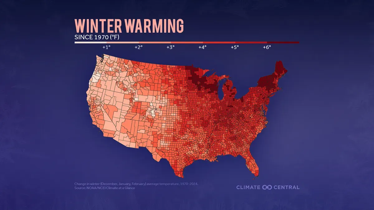
Climate Change Impacts on Winter
According to a study done at Climate Central, winter is the season that is warming up the fastest in the nation over the last several decades. While cold outbreaks still occur, they are getting shorter in duration and how cold it truly is.
Areas to the north, especially near the Great Lakes and the Northeast, are seeing more warmer-than-average winter days now compared to 1970, according to Climate Central.
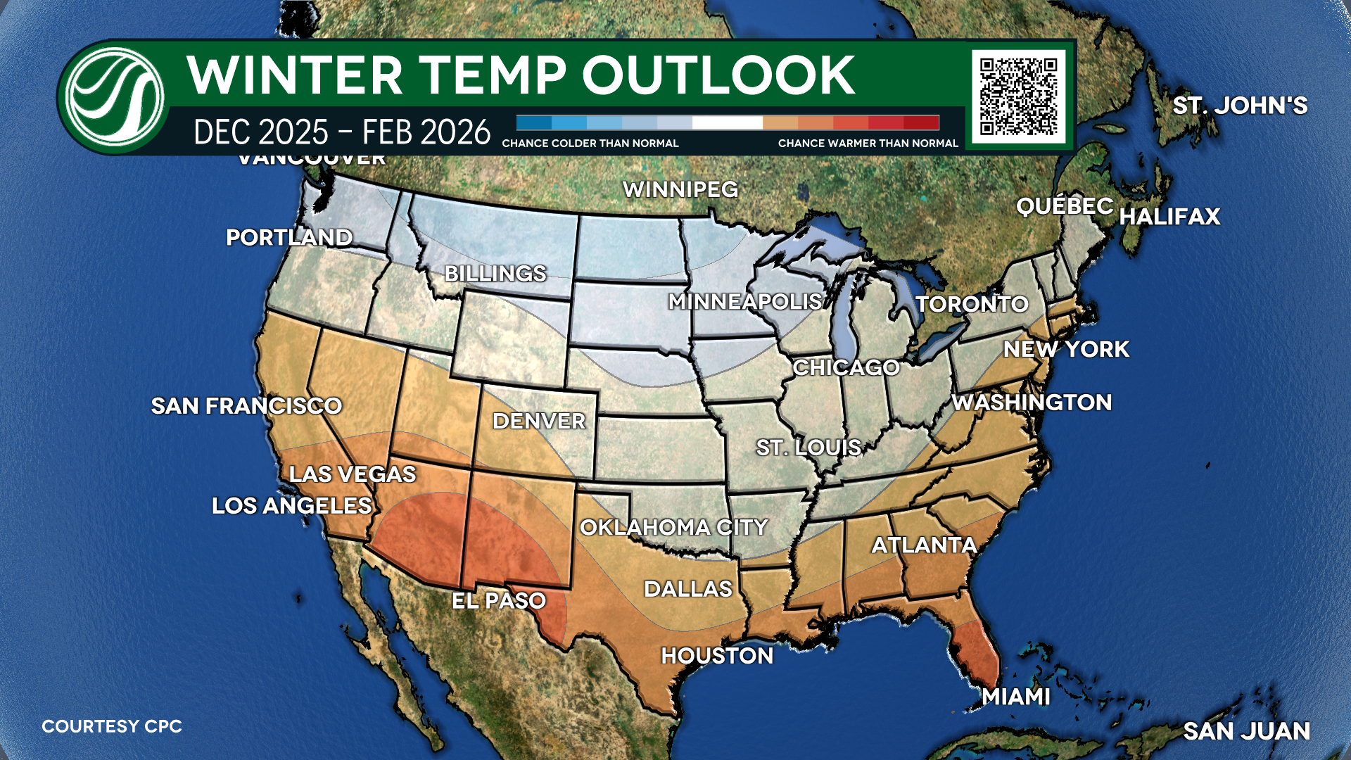
Winter 2025-2026 Official Forecast
For the 2025-2026 winter season many to the north can expect colder than average conditions. It is also favorable for areas to the south, especially the desert region of Arizona and New Mexico to have warmer than average conditions.
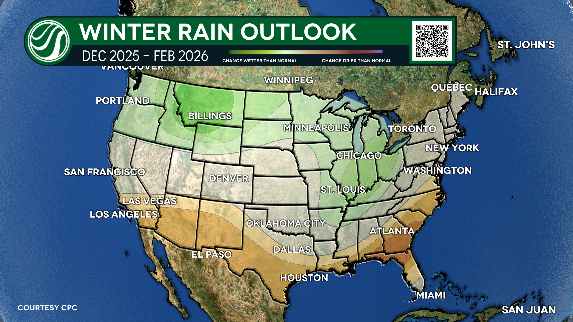
As for rainfall, the proximity to the Pacific Jet will lead to more rain. The forecast focuses on the location of cooler temperatures and where above-average rainfall will occur.
With colder temperatures and wetter-than-average conditions, this could be the perfect recipe for heavy snowfall for many this winter. And this correlates with the previous data about weaker La Niña years, where more snowfall is common in the north.
However, regardless of where you fall on this map, you WILL still have cold snaps and wet weather this winter, which could bring snow and ice to many.
If you're int he Midwest, Great Lakes or Northeast, this is your cue to prepare. Use HailTrace to pinpoints areas hit hardest by storms to identify potential roof damage zones and reach impacted homeowners first.
We took a look back at some memorable recent La Niña years and how they brought major winter weather to different portions of the country.
La Niña Years with Big Winter Impacts to Note:
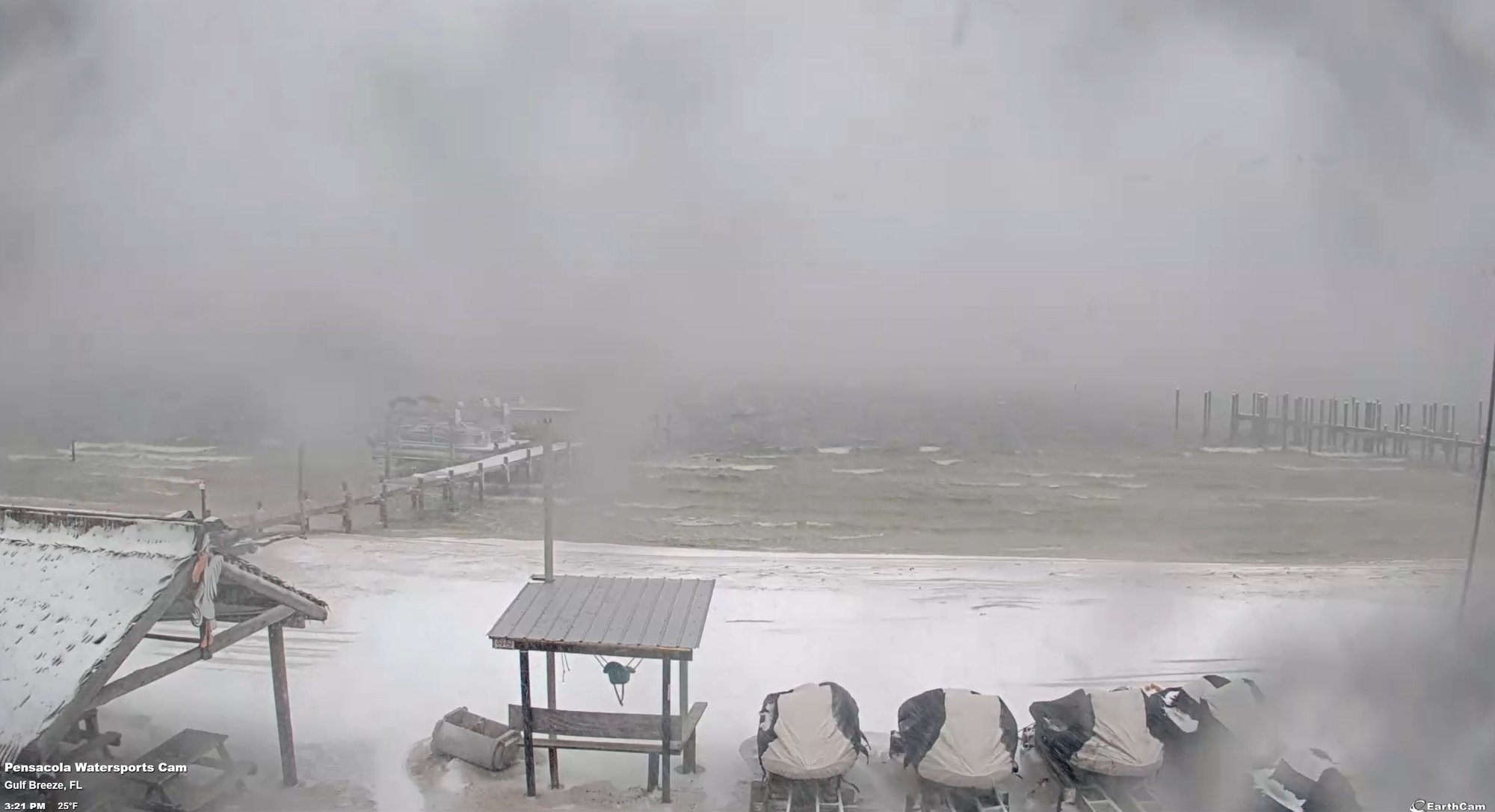
The winter of 2021, which brought the great cold snap in February along with snow across the country, down to the coast of Texas, was a moderately strong La Niña. La Niña conditions were present through the winter and were favored into early spring 2022.
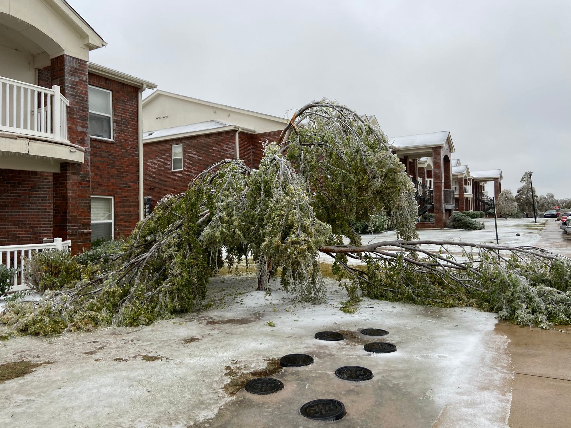
In 2020, Oklahoma had its earliest ice storm on record in October. This was at the start of a La Niña phase that was forecast to get stronger during the winter and last into early spring 2021.
All of this to say we could be seeing more snow for many in the north this winter. Weaker La Niña conditions tend to trend towards more memorable snowfall events, like 2021.
For more forecasts as winter approaches, Meteorologist Mikayla Smith and Meteorologist Taylor Cox will have updates every Monday-Friday on all HailTrace socials! Be sure to follow along.
Stay Ahead of the this La Niña Winter
HailTrace's team of 15+ meteorologists ready to provide weather data before, during, and after the storm. See unlimited storm maps, history reports, and real-time alerts in action.