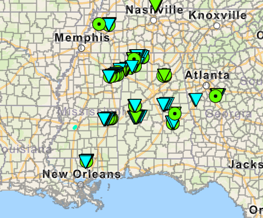
2025's Most Shocking Weather Moments
2025 was a year of wild weather across the U.S. From 5 inch hailstones to tornado outbreaks and 100 mph winds, we took a look at the top events from each month to recap how the year went! Check out the full blog at the link in our bio! #2025WeatherWrapped #2025inReview #WeatherRecap


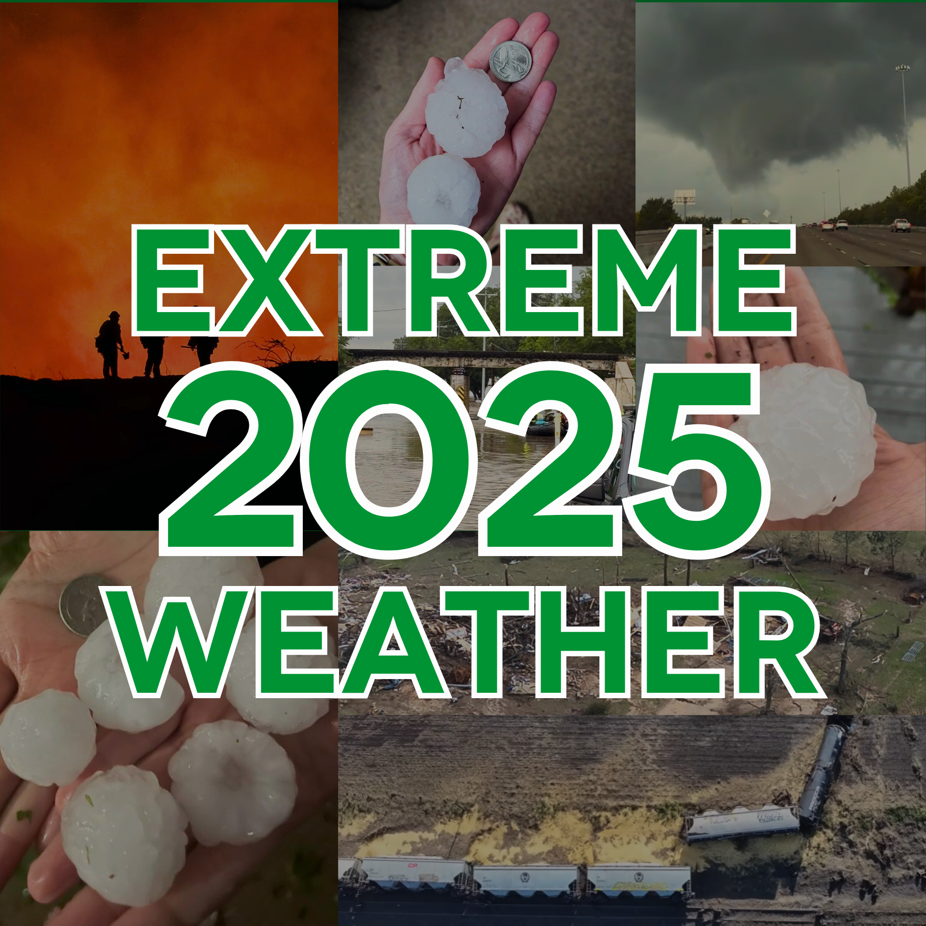
2025 was a year of wild weather across the U.S. From 5" hailstones to tornado outbreaks and 140+ mph winds, we took a look at the top events from each month to recap the year !
January
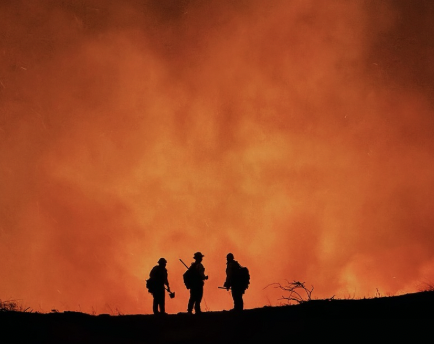
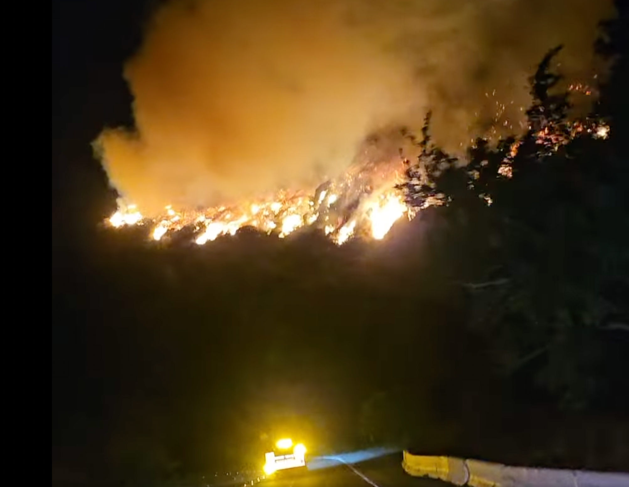
January began with an unusual series of fires that exploded across the greater LA area. This became known as the Palisades Fire, starting on the 7th and burning for 24 days, lasting until January 31st. These fires were the costliest in US history with expenses over $60 billion.
Arson was the cause of the most destructive fire, which would be known as the Palisade Fire. However, severe drought and strong Santa Ana winds fueled the fire to spread quickly. The blazes erupted into the most destructive winter fires in California history. There were over 31 fatalities.
February
Snow Across The South: The First Blizzard Warning Ever In Louisiana
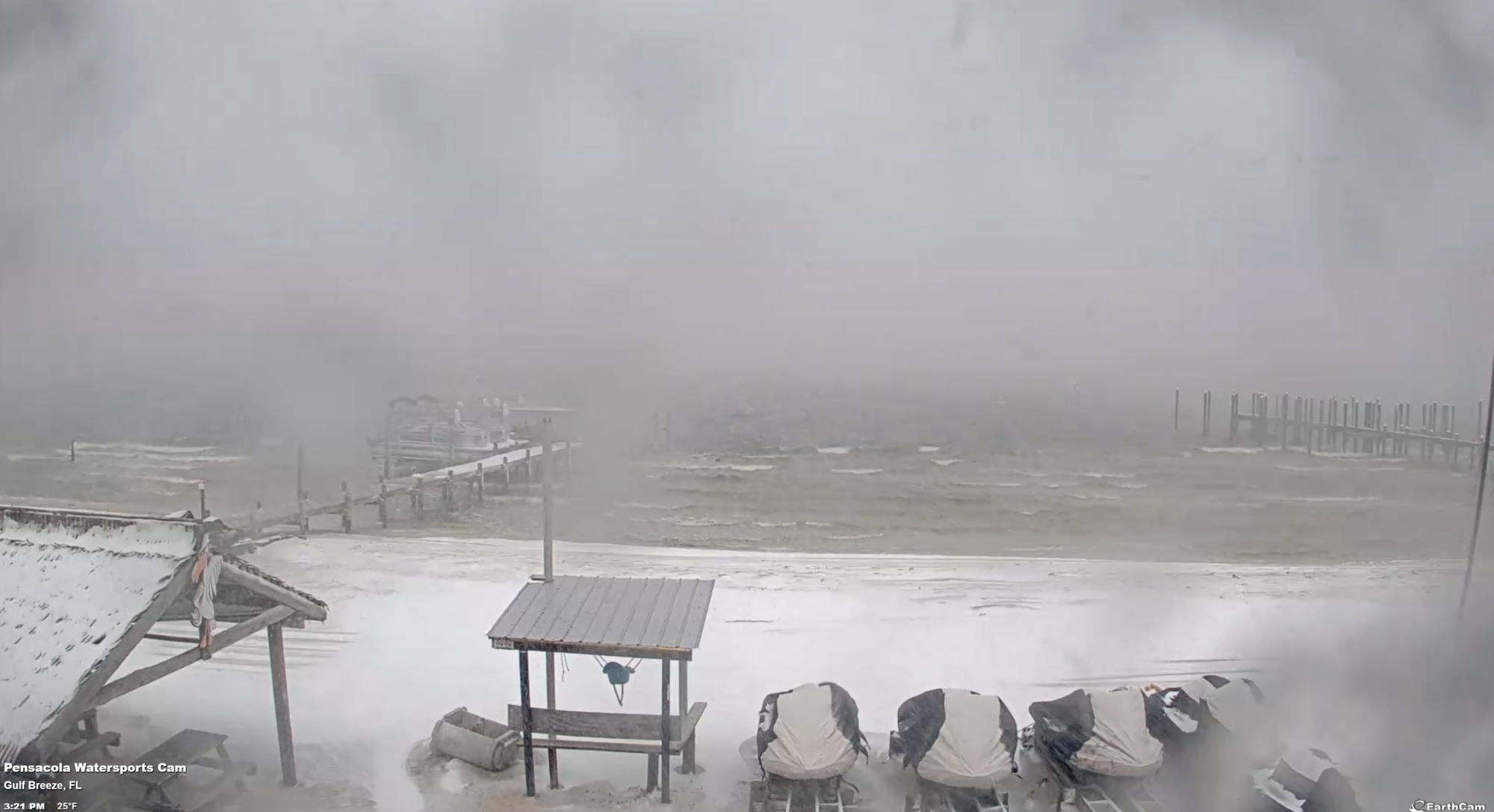
From January 20-22, a snow event occurred over the Gulf States and the coastal Deep South. For the first time ever, Louisiana experienced a Blizzard Warning. Over 7" of snow was recorded in Pensacola, Florida, the most snow in over 130 years.
Wayne County Winter Tornado
On February 12, 2025, two long-track tornadoes ripped through Wayne County Mississippi. One of the tornadoes was rated EF-3, the strongest in the area since 1988.
The EF-3 was recorded as half a mile wide and on the ground for 27 miles. It uprooted trees, pulled up water lines, and ultimately cut off 80% of water to the the community.
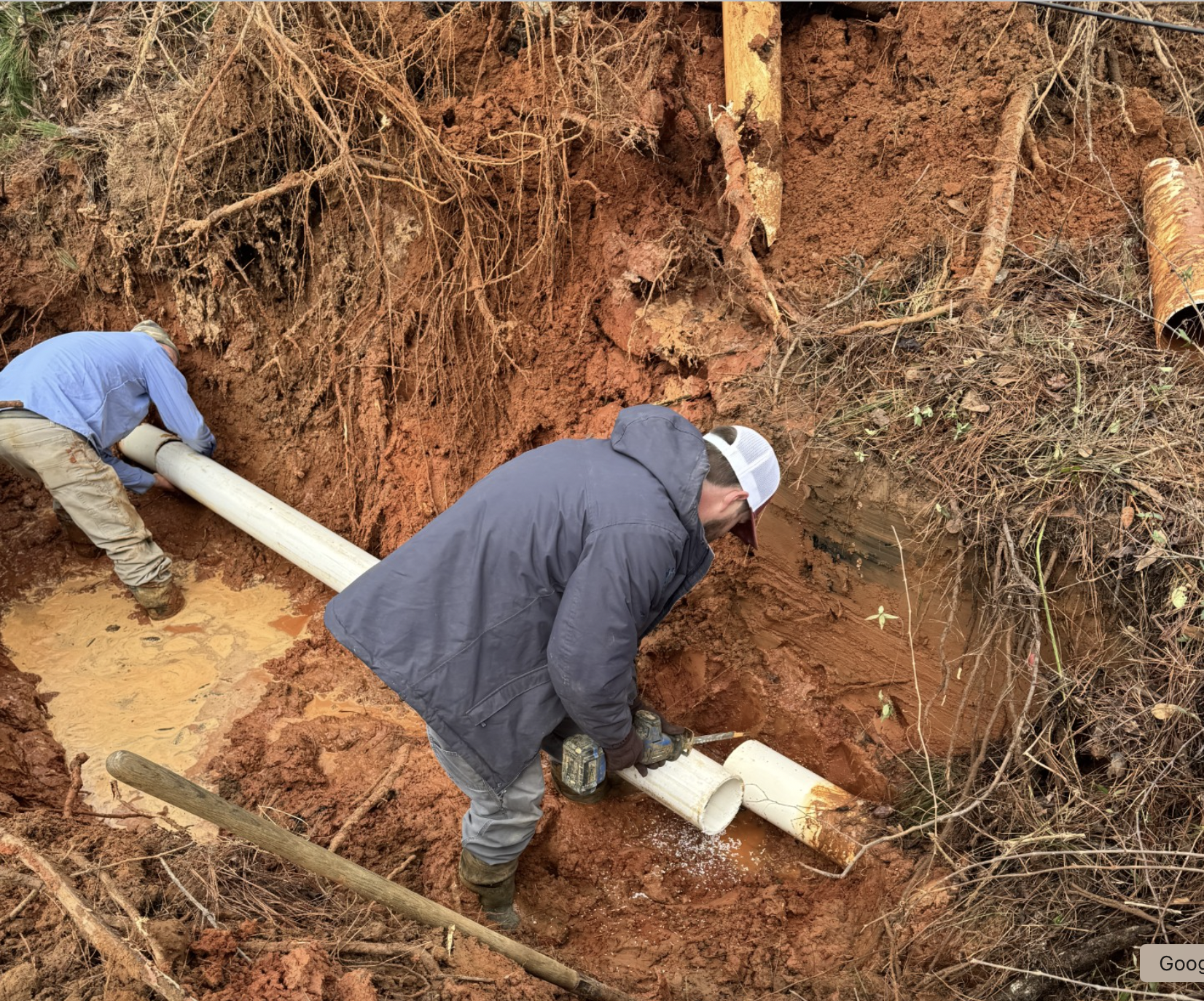
As a result of the nocturnal tornado, officials had to work overnight to identify broken water pipes. In addition to structural damage, the NWS also noted the tornado caused "deforestation" and "debarking of trees" in a nearby wooded area. A doublewide was also separated into multiple pieces and flung over 300 yards away from its original location. Some pieces were later found 30 fnjuriest up in the trees.
Thankfully, there were no deaths or injuries from the EF-3.
Wayne County Tornado Damage. Courtesy, Mississippi Emergency Management Agency.
Intense Squall Line Pushes Through Alabama
On February 15, a fast-moving squall line moved through Central Alabama. This event was ahead of a cold front with very strong winds. The squall line resulted in state-wide damaging straight-line winds and 5 confirmed tornadoes.
NWS Birmingham said that all of Central Alabama was under at least a Severe Thunderstorm Warning at some point during the system. The Montgomery Regional Airport measured wind gusts up to 70 mph that swept across the southern half of Central Alabama.
Of the 5 tornadoes, they all ranged between EF-0 and EF-1. The strongest of them all was the County Road 10: Hale and Perry County tornado.
The Hale-Perry tornado sustained maximum wind speeds of 95 mph. The EF-1 travelled 18.37 miles with a maximum width of 200 yards. Unfortunately, there were 2 injuries.
March
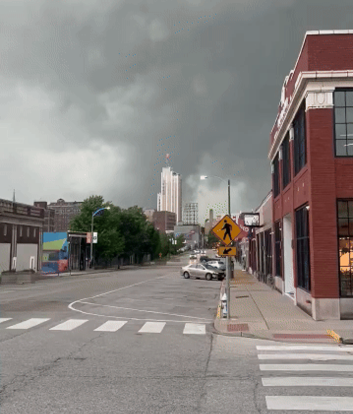
March 2025 Tornado Outbreak
On March 14-15, a powerful spring storm system triggered a severe weather outbreak across parts of the Mid-Mississippi Valley and Deep South.
A rare High Risk (Level 5 0f 5) was issued on March 15th. This was the first High Risk issued in 2025. Supercell thunderstorms produced baseball size hail, extreme straight-line winds, and numerous tornadoes.
The outbreak caused widespread impacts to property and infrastructure. It stands out as one of the most significant severe weather events of the 2025 spring season.
DFW Hailstorm
A line of thunderstorms tracked across the Dallas-Fort Worth metroplex on March 25th, during the evening and into the early morning hours. Multiple storm cells fired around DFW, dropping hail the size of golf balls in Dallas, Johnson County, and Tarrant County.
Hail footage from home. Courtesy, @Ryno_Pittman.
This system soon became a 5-star hail event. This March hailstorm in DFW was a classic early-spring system for North Texas, which brought medium to large hail across the metro with considerable property and vehicle damage.
Oh Hail... AGAIN... AND AGAIN!
From March 29-31, the Central and Southern Plains experienced 3 consecutive days of severe hailstorms, adding several 4-star hail maps to the 2025 list!
Several storms produced hail ranging from 2.50-3.00", causing dents and busted windshields to vehicles and property across multiple states. Thousands of homes were impacted each day, with local reports noting 'high volume hail' and disruptions of power and traffic.
This rare multi-day hail outbreak marked one of the most significant early-spring severe weather periods of 2025.
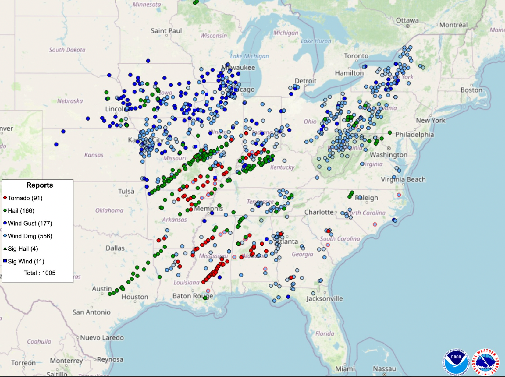
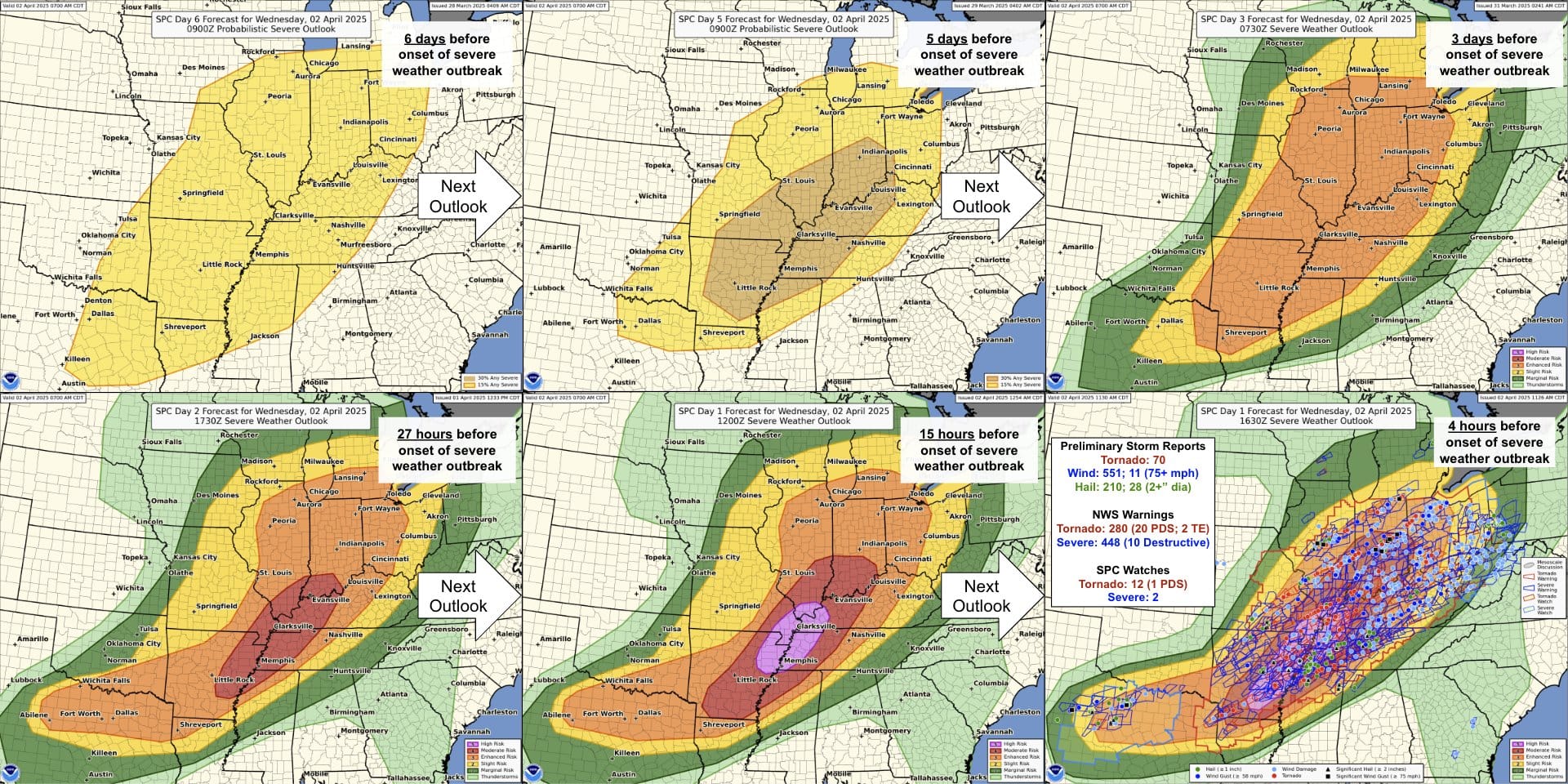
April 2nd: The Day of the High Risk
This was the second (and last) High Risk of 2025. The SPC highlighted an area for potential severe weather 5 days before the event began. By April 2nd, they upgraded the storm risk to the maximum level, a High Risk. There were 70 tornadoes, over 500 high wind reports and 210 large hail reports from this outbreak!
5-Star April Hailstorm
For the first time in West Virginia history, there was a 5-Star Hail Map. On April 14th, this hail-producing supercell traveled over 300 miles, from Ohio to Virginia. This storm crossed over Charleston, WV where it dropped golf ball size hail to the city!
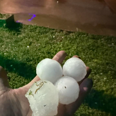
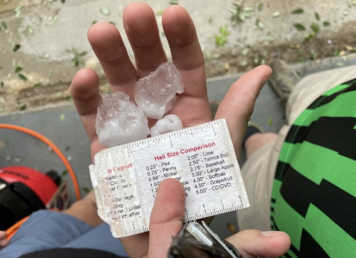
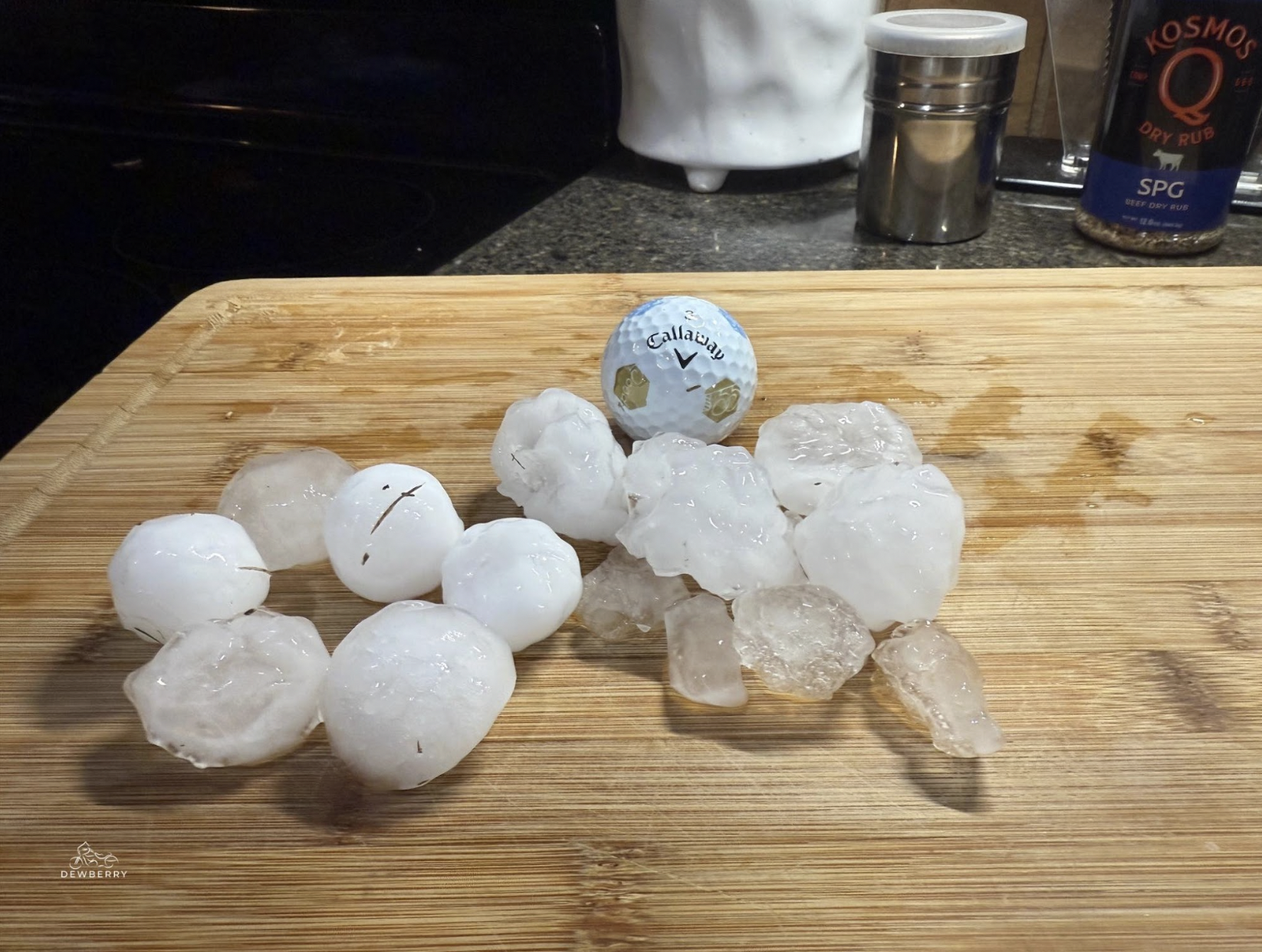
DVD-Sized Hail Warning: 5" Stones
Radar of the 5" Hailstone Warned Storm
A rare severe thunderstorm warning was issued for the Texas Panhandle on April 24th, 2025. The warning included details of 5" hail likely near Matador, TX! To put that into perspective, that is the same size hail as a CD/DVD falling from the sky! These large hailstones only happen once or twice a season.
May
May Outbreak: Spawning 60 Tornadoes
From May 15-16, a major tornado outbreak swept across the Midwest and Ohio Valley producing at least 60 confirmed tornadoes!
The most violent tornado was an EF-4 that carved a 16.5-mile path through Williamson County, Illinois, with estimated peak winds around 190 mph. It destroyed homes and prompted a rare 'Tornado Emergency' by the NWS.
May OKC Hailer
On May 17th, severe storms swept through central Oklahoma and Oklahoma City, producing widespread large hail and strong winds. This was part of a major spring severe weather pattern.
A swath of hail up to 4" in diameter was reported in the OKC region, with thousands of properties impacted by 1"+ and 1.75"+ hail. Shattered windshields and trees stripped of their leaves were a common scene around the city.
This hailstorm represents one of the most intense hail events in the May outbreak.
Arnett, OK Tornado
From May 18-20 a major tornado outbreak occurred over the Great Plains and Central US. This outbreak produced 133 confirmed tornadoes and caused widespread severe weather across multiple states.
Specifically in Arnett, OK, a strong, textbook EF-3 tornado touched down on May 18th as part of the outbreak. It carved a path through rural Ellis County, where there was significant wind and hail as large as 4.5" within the storm's vicinity.
As the second May tornado outbreak, this system featured powerful supercells and caused billions in damage. Numerous injuries occurred across the Plains and Midwest, marking this outbreak as one of the most active and dangerous weather episodes of spring.
Our team of storm chasers and meteorologists at HailTrace caught striking footage of the Arnett tornado.
A part of the same storm system as the Arnett tornado, a lightning strike struck a police car in Newcastle, OK.
Video from NewCastle Emergency Management
May Austin, TX Hailstorm
On May 28, Austin, Texas was struck by a record-breaking 5-star hailstorm.
Part of a larger late-May weather pattern, hail up to 3-3.50" pummeled the city. This forced residents and crews to shovel massive accumulations of hail off the roads just to pass through. Essentially, streets were temporarily buried under drifts of ice.
Cedar Park in Austin hail event. Courtesy, Kelley Hoggatt.
The storm disrupted power and traffic and impacted thousands. This storm marked one of the most intense hailstorms of the 2025 Texas storm season.
June
DFW Hailstorm
On June 1st, the Dallas-Fort Worth metroplex was hit by a 5-star hailstorm, producing hail up to 3.25" inches in diameter. The storm impacted tens of thousands of vehicles, homes, and commercial properties and caused temporary road closures.
This 5-star hailstorm is one of the most intense hail events of 2025 for Texas storm season and highlights the ongoing vulnerability of the DFW area to late spring storm activity.
Lubbock Hailstorm
Lubbock, TX HailTrace Hail Forecast
Lubbock, Texas was hit by a severe hailstorm on June 5, during a early-June severe weather outbreak across the Southern Plains. The storm, originally warned for a tornado, quickly turned into a hailer while approaching the city.
Lubbock streets were temporarily clogged by ice accumulation in some neighborhoods. This event contributed to one of the more intense periods of hail for Texas storm season in 2025, following multiple 5-star hail events in nearby DFW and Austin earlier in may and June.
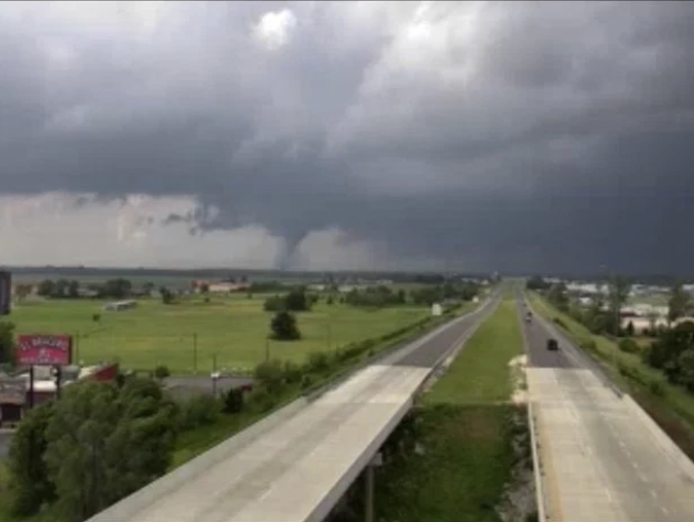
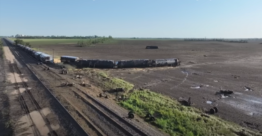
Enderlin EF-5 Tornado
On June 20, 2025, a deadly tornado struck Enderlin, North Dakota, part of an overnight derecho and severe storm outbreak across the Northern Plains.
Initially rated EF-3, the National Weather Service later upgraded it to EF-5, marking North Dakota’s first EF-5 tornado since Moore, Oklahoma in 2013.
The tornado produced winds exceeding 210 mph, leveling farmsteads, uprooting massive trees, and derailing 33 train cars, including 19 loaded grain hoppers and 14 empty tankers—one of which landed 475.7 feet from its track.
Tragically, 3 people were killed, making it the deadliest North Dakota tornado since 1978. Forensic evidence, such as tanker cars lofted into the air and complete destruction of homes, confirmed the storm’s extreme intensity.
July
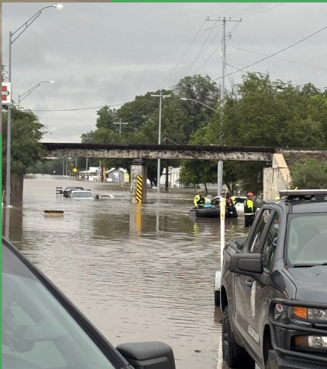
Central Texas Flooding
The Central Texas Flooding on July 4, 2025 was the deadliest U.S. flood event in nearly 50 years.
The day before flooding started, Wednesday, TDEM called for swift water rescue teams and equipment to be moved into Texas Hill country. The NWS also added extra staff for Wednesday and Thursday to prepare for the significant event.
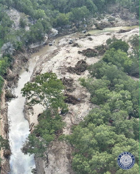
At 1:18 PM a Flood Watch was issued for Texas Hill Country and at 11:41 PM the first Flash Flood Warning was issued by the NWS.
Thursday at 12:26 AM, NWS posted 'Flash flooding overnight likely with significant impacts possible.' By 1:14 AM a Flash Flood Warning was put into place with a "Considerable" tag issued. This tag triggered Wireless Emergency Alerts on phones in the area.
By 3:06 AM, Flash Flood Warnings were issued with wording saying: 'A very dangerous flash flooding event is ongoing, turn around, don't drown.' By 4:03 AM, a Flash Flooding Emergency was issued.
At 5:16 AM, the city of Kerrville Police Department posted 'Anyone near the Guadalupe River needs to move to higher ground now.'
The river rose 26 feet in 45 minutes. Unfortunately, the tragic situation resulted in 135 deaths.
August
Cheyenne 4-Star Hail Event
On August 1st, severe thunderstorms pounded Cheyenne, Wyoming and southeast Wyoming, producing very large hail up to approximately the size of a baseball.

The hailstorm impacted over 8,000 properties with 2.50"+ hail and more than 28,000 with 1.75" hail in the region.

Mount Pleasant Lightning Strike
On August 11th, a sudden bolt of lightning struck near Highway 17 and Shelmore Blvd in Mount Pleasant, South Carolina.
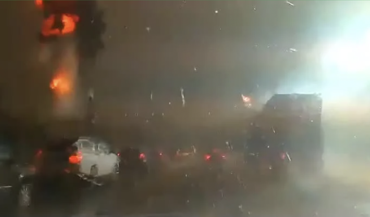
During a strong summer thunderstorm, lightning struck a transformer, causing an explosion with a fire-ball appearance. It shot bursts of flames into the air and sparked widespread power outages and traffic disruptions.
This shot was caught on a police dashcam and shared by the Mount Pleasant Police Department. Fortunately, no injuries were reported and power was later restored that afternoon.
September
Wichita Hailstorm

A powerful line of supercell thunderstorms marched through central and south-central Kansas, producing intense hailstorms down I-35. On September 3, two major hailstorms slammed Wichita, KS! 81,000 structures were impacted with with 2.50" hail. This marks the last 5-star event for 2025.
October
Imelda Hits Bermuda
While no hurricanes made landfall on states this year, the Atlantic was still very active! On October 1, Hurricane Imelda struck Bermuda as a Category 2 hurricane. With sustained winds near 100 mph, dangerous surf and heavy rain rocked the small island. While not a direct hit, Imelda passed very close to the island, prompting numerous hurricane warnings.
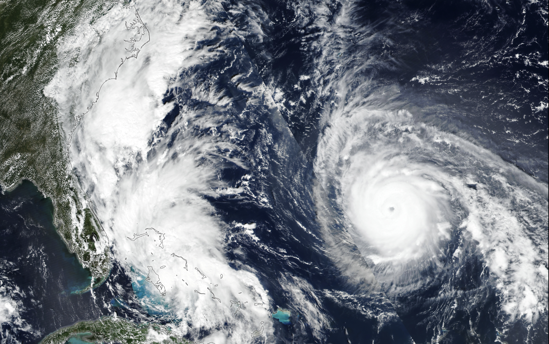
Imelda caused power outages, coastal flooding, infrastructure damage and more. After impacting Bermuda, the hurricane moved back into the Atlantic and weakened. This hurricane marks one of the most significant tropical cyclone impacts of the 2025 season for the island.
OKC Hailstorm
On October 23, severe thunderstorms swept through the Oklahoma City metro and produced hail up to 3" in diameter. This was the second major hailstorm to impact over 10,000 residents in OKC in 2025.
This Fall hail event highlighted that the Plains can still experience significant weather well into October.
This storm was deemed a 4-star hail event.
Melissa Hits Jamaica
On October 28, Hurricane Melissa hit Jamaica. Melissa is the strongest Category 5 in the Atlantic Basin at landfall to ever be recorded.

Melissa made landfall in southwestern Jamaica with sustained winds near 185 mph, the strongest on record to hit the island. It brought 15-30 inches of rain and life-threatening storm surge.
Widespread flooding and landslides in Jamaica occurred across multiple parishes. Extensive infrastructure damage and most of the island without power was a result of Melissa. Hospitals were damaged and left powerless, forcing thousands into alternative shelters. There were dozens of confirmed fatalities and many injuries.
November
South Texas Hailstorm
On November 1, a strong hailstorm struck South Texas in areas like Corpus Christi, Portland, Taft, and surrounding Coastal Bend communities.

Intense thunderstorms swept alongside a strong cold front with Gulf moisture. The storm produced large hail up to baseball size with strong wind gusts impacting tens of thousands of properties.

This caused one of North America's largest hail-related wildlife mortality events, killing or injuring over 2,000 coastal birds, primarily brown pelicans and other species, on rookery islands in Corpus Christi Bay and Baffin Bay.
Houston Metro Tornadoes
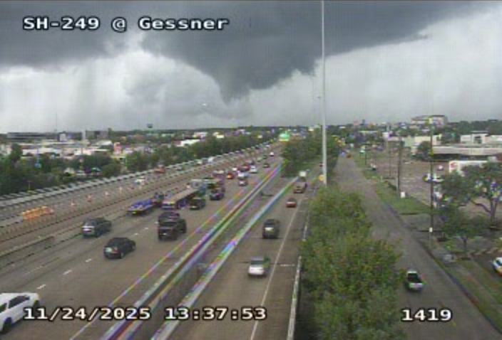
On November 24, a severe thunderstorm and cold front triggered tornadoes across the Houston metro and northwest Harris County. More than 100 homes were in the path, uprooting trees and downing power lines.
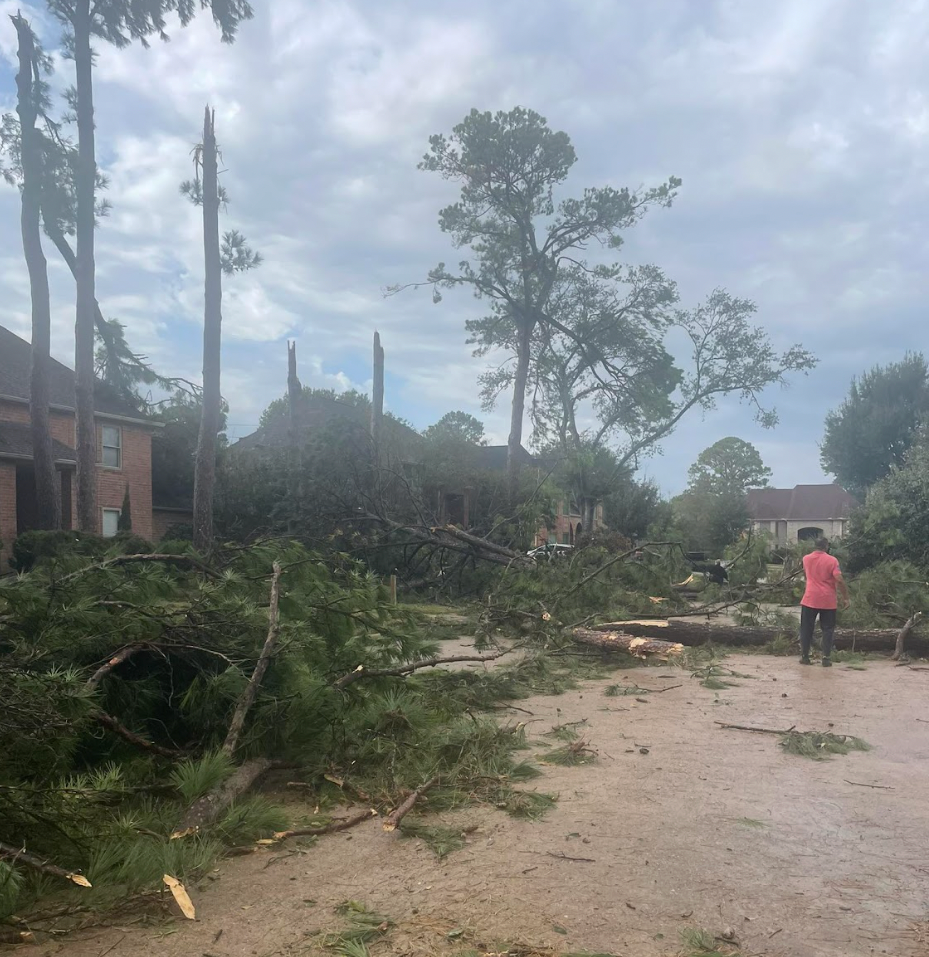
2 tornadoes hit the Houston Metro. An EF-1, near Riata Ranch with 110 mph winds and an EF-2, near Klein, with 116 mph winds. The EF-2 carved a several-mile path through populated neighborhoods, ripping roofs off and breaking windows.
The storm forced a ground stop at Bush Intercontinental Airport, contributing to travel disruptions during the Thanksgiving holiday. There were no reported fatalities.
December
Washington State Flooding
From December 9-13, record-breaking atmospheric rivers unleashed historic rainfall across western Washington State, which produced major river flooding and landslides.
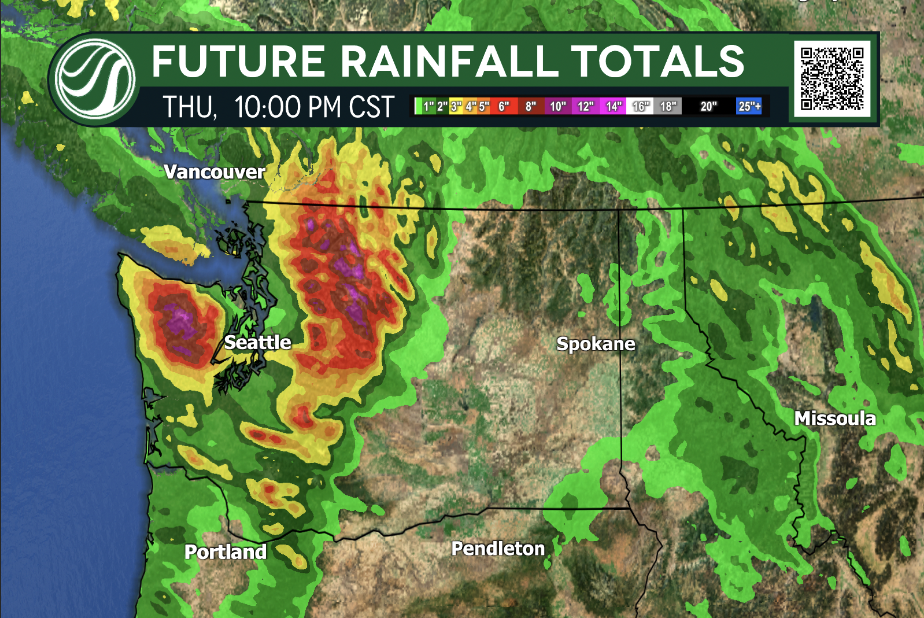
The Skagit, Snohomish, Green, Cedar and Nooksack Rivers topped all-time flood levels with the Skagit River cresting near 40 feet. The extended rainfall totaled 15-24 inches in some areas, forcing tens of thousands of residents to evacuate and prompting hundreds of emergency rescues.
Widespread infrastructure impacts occurred, including overtopped levees, compromised bridges, highway closures, mudslides, and landslides. Power outages were so detrimental that they led to event cancellations like annual town Christmas festivals.
This was one of the most significant flood disasters in Washington State's history.
Extreme Wind
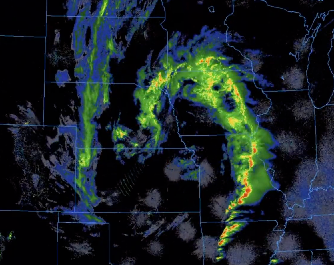
A powerful late-season winter storm swept across Montana, the Northern Plains and Upper Midwest which produced hurricane-force gusts exceeding 100 mph in exposed mountain passes and ridges.
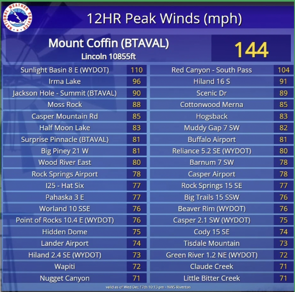
On December 17, wind gusts over 100 mph were recorded across the northwestern US.
The storm downed trees and power lines, causing widespread power outages. In Montana, essential highways were closed or heavily advised not to travel on. The intense wind speeds created blizzard-like conditions with reduced visibility and hazardous travel.
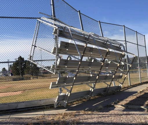
Montana declared a state "Wind Disaster", while emergency warnings and utility disruptions affected thousands across multiple northern states. This is marked as one of the most severe wind events of 2025 in the northern US.
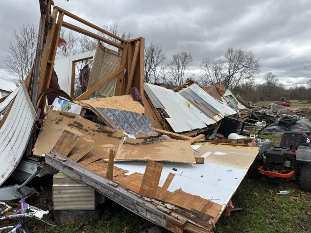
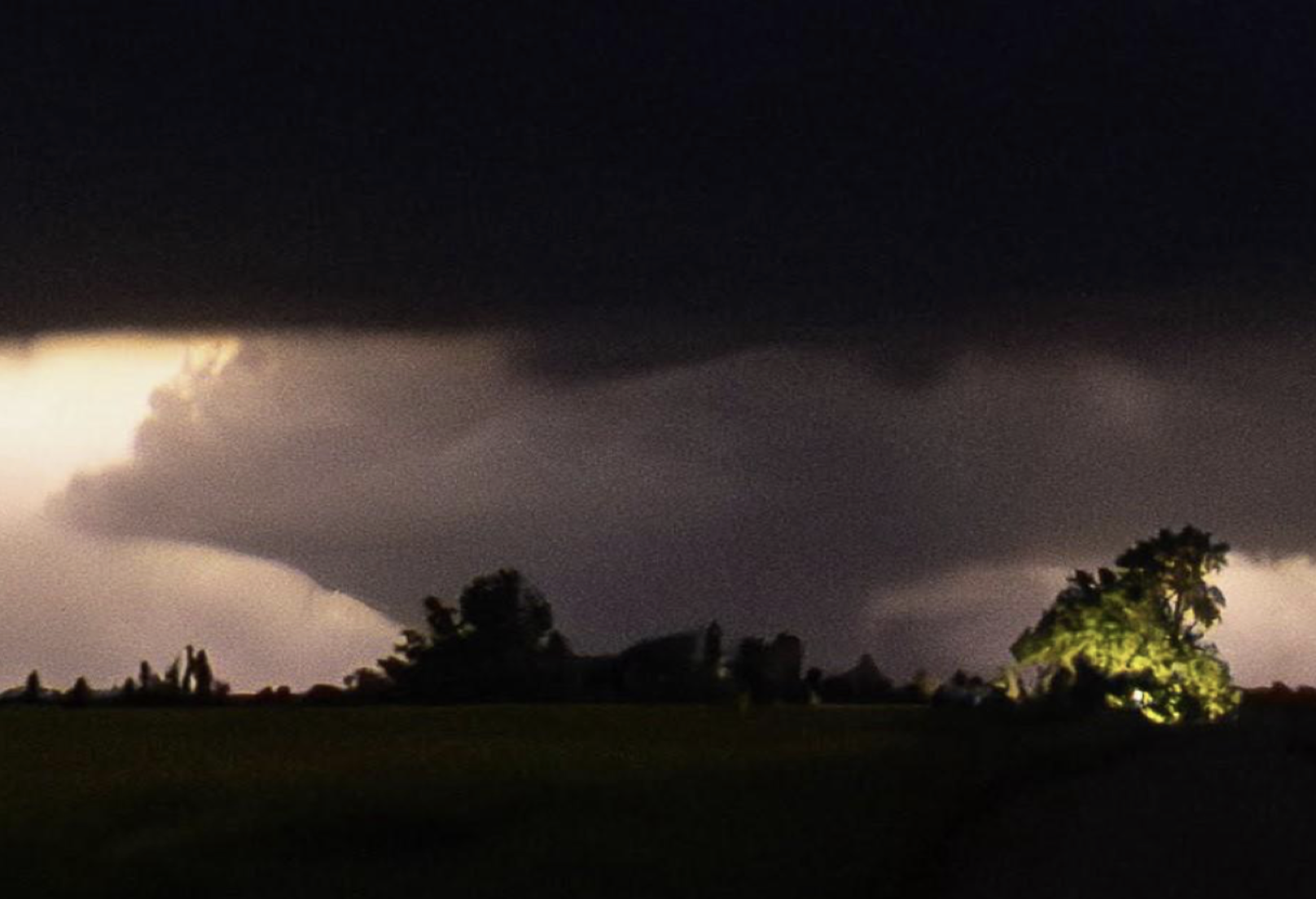
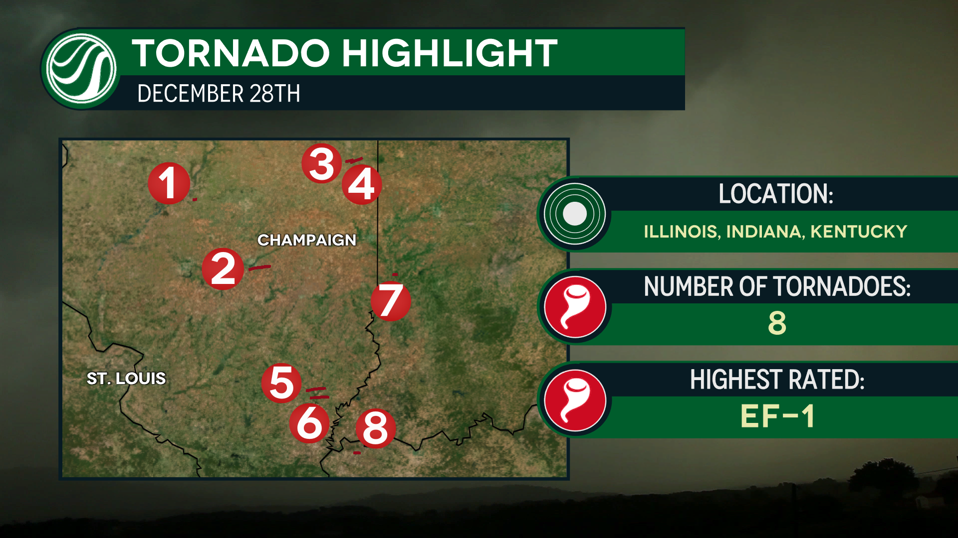
Post Christmas Tornado Outbreak
Just days after Christmas, on Sunday, December 28th, 2025, a tornado outbreak occurred across the Midwest. Over 12 tornadoes have been confirmed by meteorologists at HailTrace.
This event started early on Sunday morning. The first round of storms resulted in an EF-1 tornado near Groveland, IL, just south of Peoria!
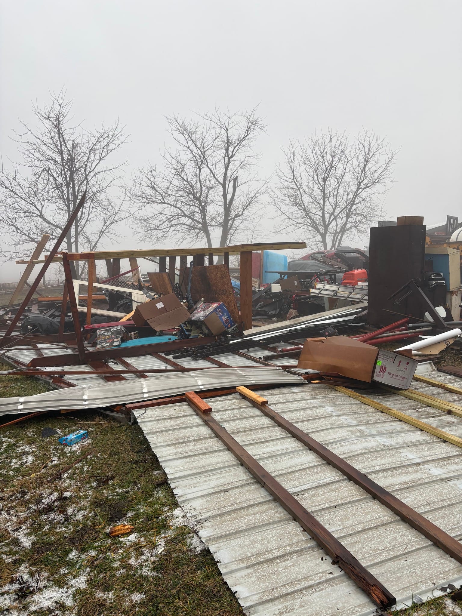
The second round of storms was much more severe, with more confirmed tornadoes and over 20 reports of strong straight line winds.
This is the second December in a row with late season tornado activity in the U.S.
2025 was a rollercoaster from start to finish. HailTrace covered each event above and will continue to bring you live coverage in 2026. Stay tuned for all the forecasts as January 2026 kicks off!