2025 Atlantic Hurricane Season Recap
The 2025 Hurricane Season featured four major hurricanes and no U.S. landfalls. Although it may have seemed slow, the Atlantic still produced several record-breaking storms. Meteorologist Mikayla Smith breaks down each system and its impact.

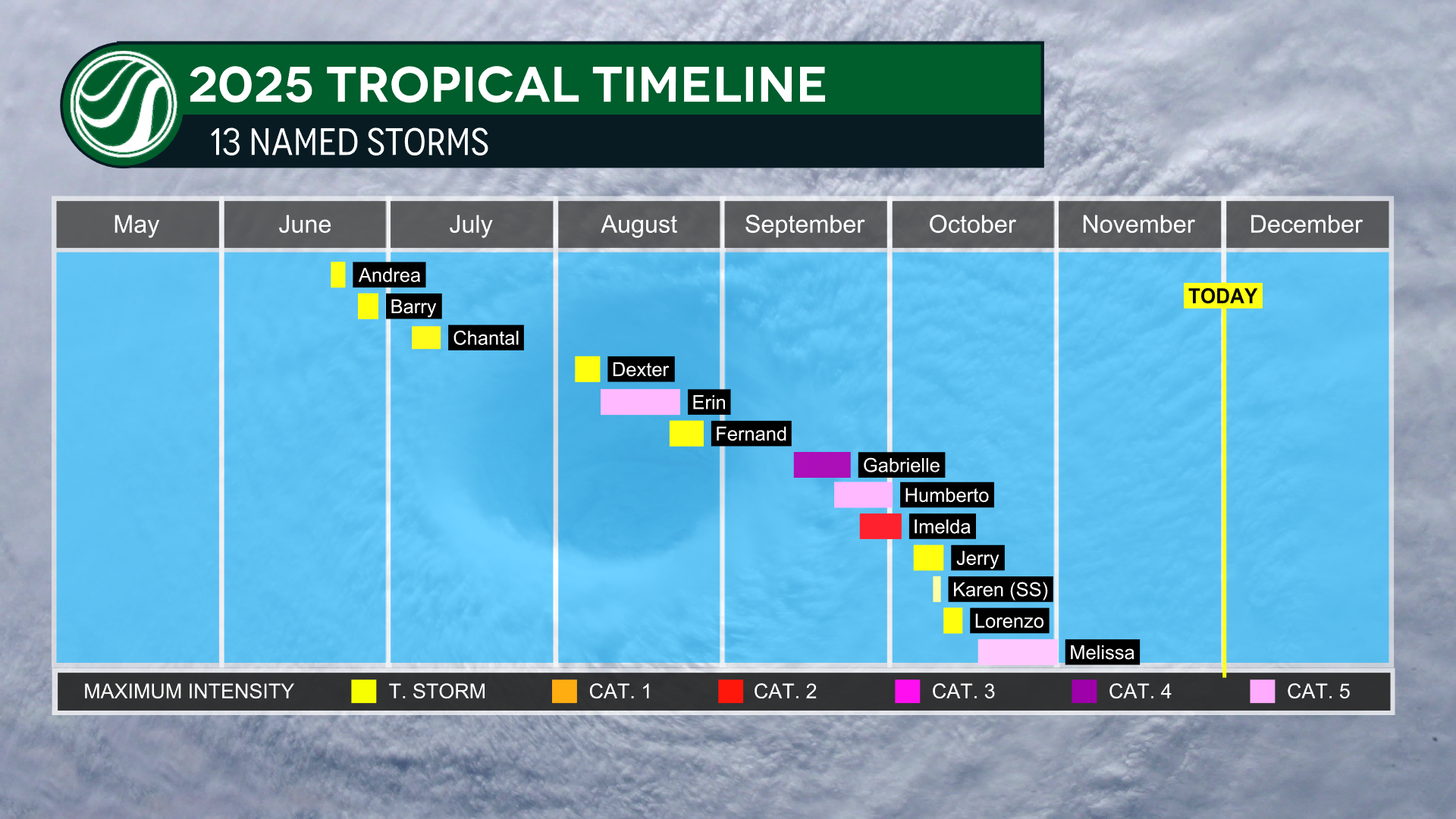
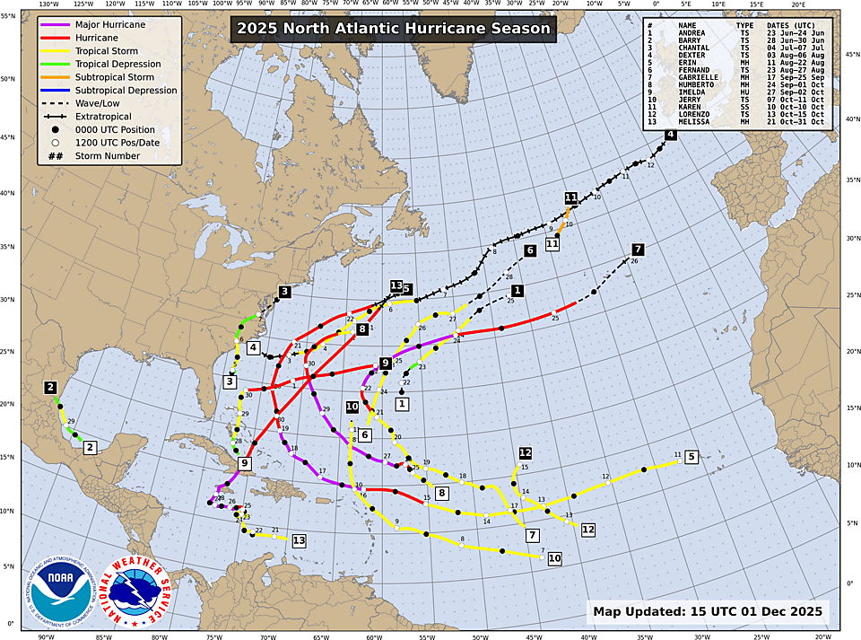
The 2025 Atlantic Hurricane season has officially come to an end! This season was marked with near normal activity in the Atlantic, with 13 named storms officially between June 1st to November 30th.
This was the 8th season this century where no hurricane made landfall in the U.S.
This mild hurricane season, with no U.S. landfalls, meant far fewer tropical weather disasters, which greatly reduced the usual surge for repairs and cleanup. While that offered a break from high-stress disaster work, it also led to a noticeable dip in seasonal revenue for many who rely on storm-related projects and research.
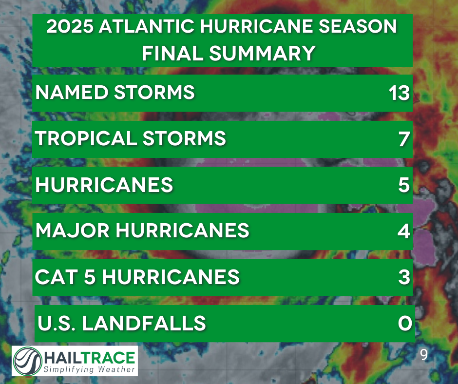
While it may have felt slow, this season was actually very average, according to the National Oceanic and Atmospheric Administration (NOAA). The average hurricane season sees 14 named storms, 7 hurricanes, and 3 major hurricanes.
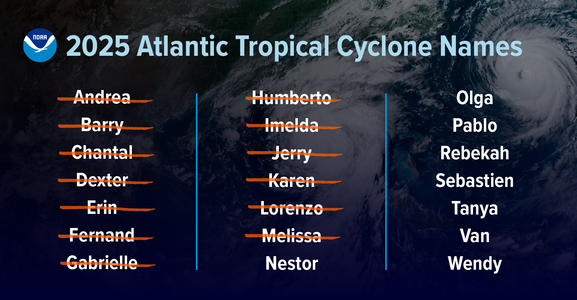
Still, this was the lowest number of named storms for a hurricane season in a decade! The last time we had 13 or less named storms during the Atlantic season was in 2015, when there were only 12 named storms. Additionally, for the first time since 2018, there was also no activity in the Atlantic for the entirety of November.
Not a single hurricane made landfall in the U.S this year. The only landfalling system was Tropical Storm Chantal, which brought hazardous conditions to the East Coast in early July.
The storms this season could be described as few... but mighty. 4 cyclones became major hurricanes, which is slightly above the seasonal average.
Major Hurricanes
Hurricane Erin was the first major hurricane of the season and it achieved Category 5 status. While it did not make landfall, it did bring tropical storm conditions to the Outer Banks of North Carolina, which lead to an increased storm surge and strong rip currents along the coast.
Hurricane Erin was the First Category 5 Hurricane This Year
Erin tied for the 3rd fastest 24-hour pressure drop when it rapidly intensified from 998 mb to 915 mb. In the same time, the winds also tied for the 5th fastest 24-hour rapid increase from a 75 mph Category 1 storm to a monster 160 mph Category 5 hurricane.
Hurricane Gabrielle was the next hurricane to form in mid September, just after the climatological peak of hurricane season on September 10th. It also reached major hurricane status with maximum winds of 120 mph.
Hurricane Humberto came shortly after Gabrielle and was the second hurricane to reach Category 5 status of the 2025 season. At the same time that Humberto was spinning out in the Atlantic, Imelda also formed.

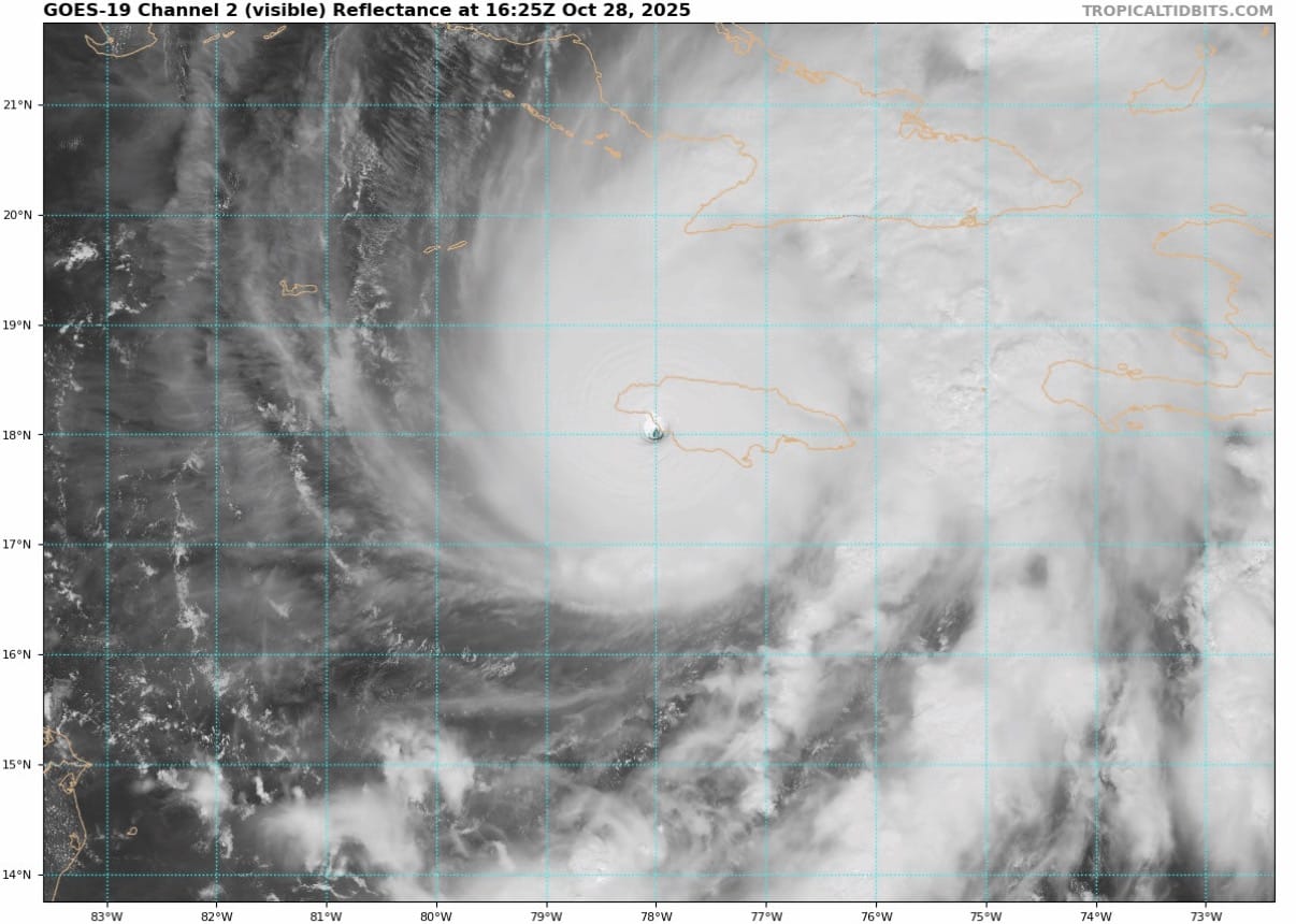
Hurricane Melissa was the 4th major hurricane of the 2025 season and 3rd Category 5 storm to form in the Atlantic. Hurricane Melissa underwent rapid intensification, much like other storms this season. The pressure dropped 90 mb in 72 hours while the winds increased 115 mph, from 70mph to 185 mph when it made landfall. It officially became the strongest hurricane in the Atlantic Basin when the pressure dropped to 892 mb at landfall.

Melissa was well forecasted by the National Hurricane Center. Four days before the hurricane officially made landfall on October 28, the NHC had a projected path that took the hurricane over the western half of Jamaica. From this initial forecast to actual landfall, the track varied by only 13 miles!
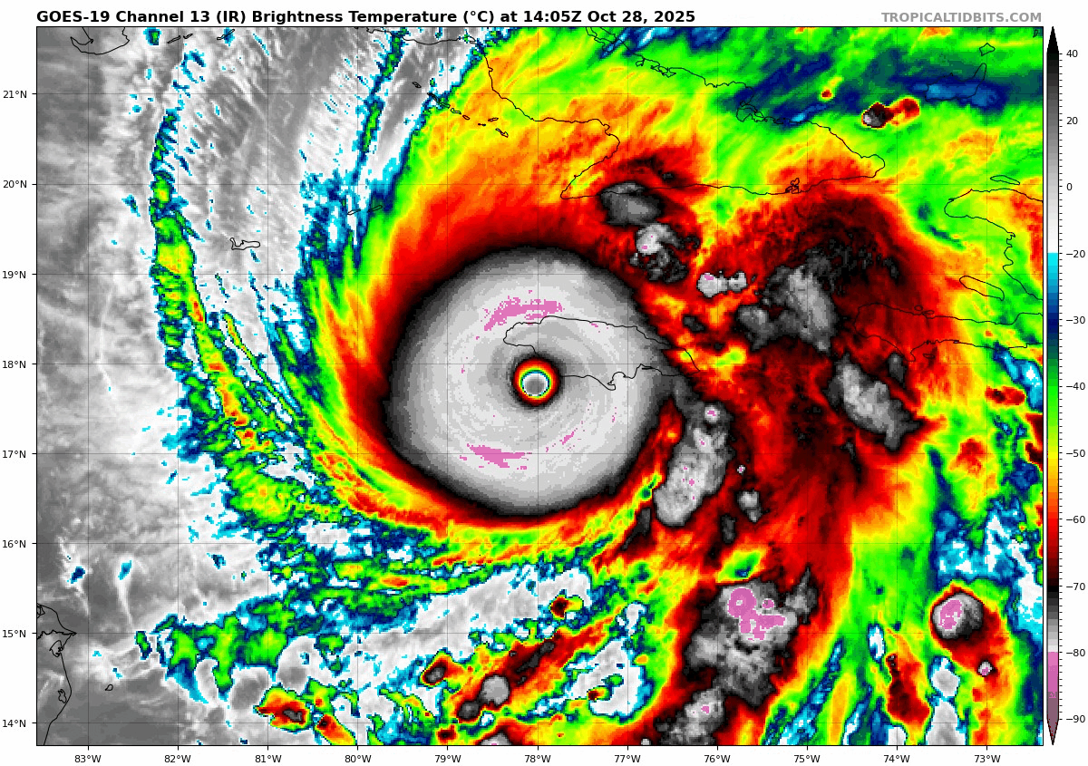
“NHC’s intensity forecasts for Melissa outperformed every model at nearly every lead time and provided almost three days of advance notice that Melissa would make landfall in Jamaica as a powerful Category 5 hurricane,” said Michael Brennan, Ph.D., director, NOAA’s National Hurricane Center.
This was the first time that the NHC was able to forecast a storm reaching Category 5 status so many days in advance where models suggested such a low probability of this occurring.
Key Takeaway: The accurate tracking of the NHC goes to show how import research continues to be in getting better at predicting this monster storms.
Historic Notes
No other year with similar or less total activity in the Atlantic has had 3 Category 5 hurricanes. That makes this season the second-most on record to have 3 Category 5 hurricanes in one season. The 2005 hurricane season had the most Category 5 hurricanes with 4!
“Fortunately, short-term weather patterns largely steered tropical systems away from the United States.” Ken Graham, the director of NOAA's National Weather Service, and previously the director of the National Hurricane Center states.
Hurricanes
Hurricane Imelda was the only hurricane in the 2025 Atlantic season to not achieve major hurricane status. Imelda formed shortly after Hurricane Humberto in late September, as the final storm to form that month. It strengthened into a Category 2 hurricane with sustained winds of 100 mph before hitting Bermuda on October 1st. After passing over Bermuda it quickly lost strength and became a post-tropical low on October 2nd, completing its extratropical transition.
Video of Imelda making landfall in Bermuda late on October 1st
Tropical Storms
Tropical Storm Andrea was the first official named storm of the season and did not bring much to the table. It was a very short lived Tropical Storm, only warned for two days, that formed just east of Bermuda. Surrounded by high pressure systems it stayed weak and quickly fell apart.
Tropical Storm Barry did not make landfall in the U.S. but brought major impacts, specifically to Texas. Barry made landfall on the coast of Mexico . The NHC states in its Tropical Cyclone Report:
Barry and its remnants were not the primary cause of the devastating floods that occurred in the central Texas Hill Country on 4–5 July.
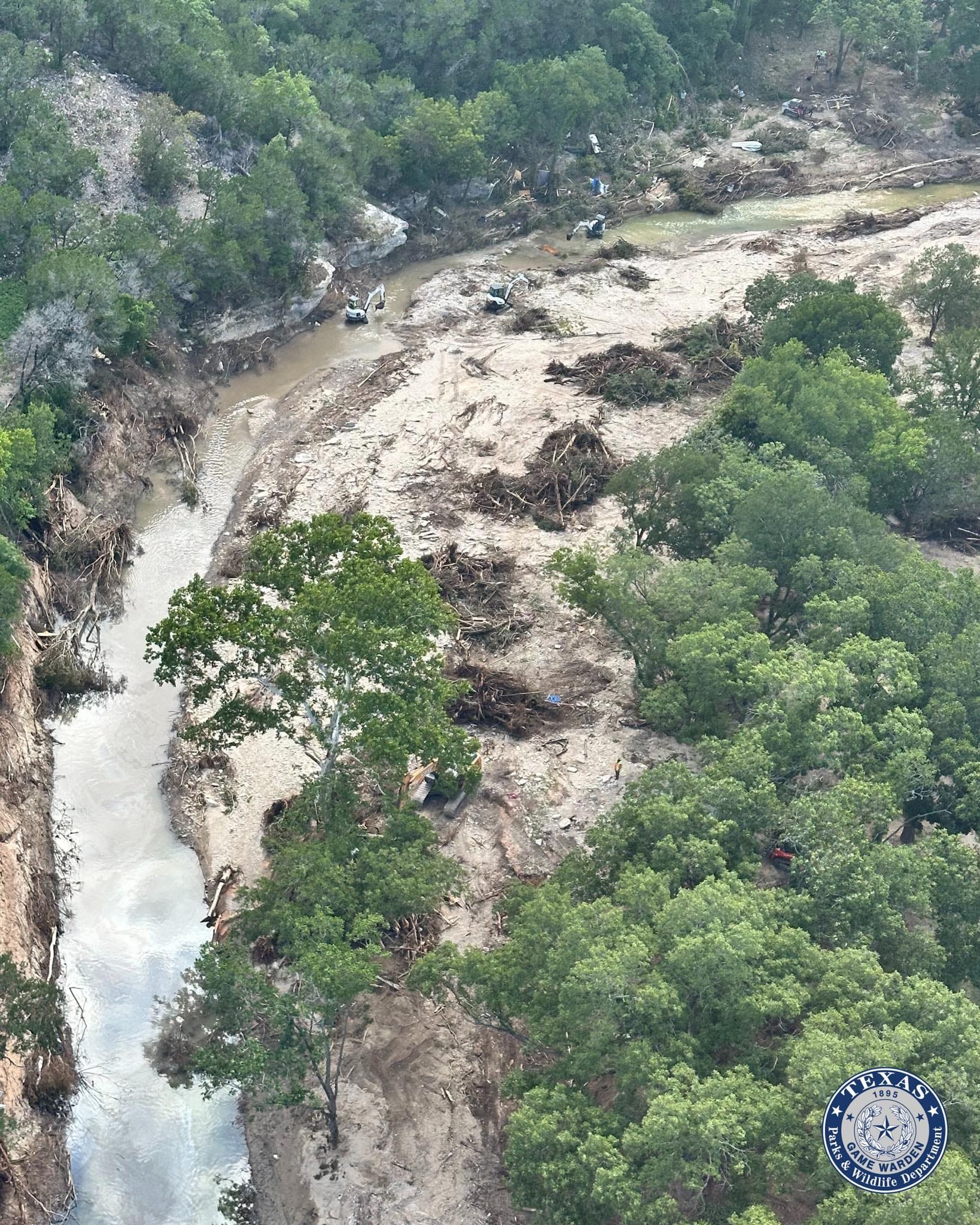
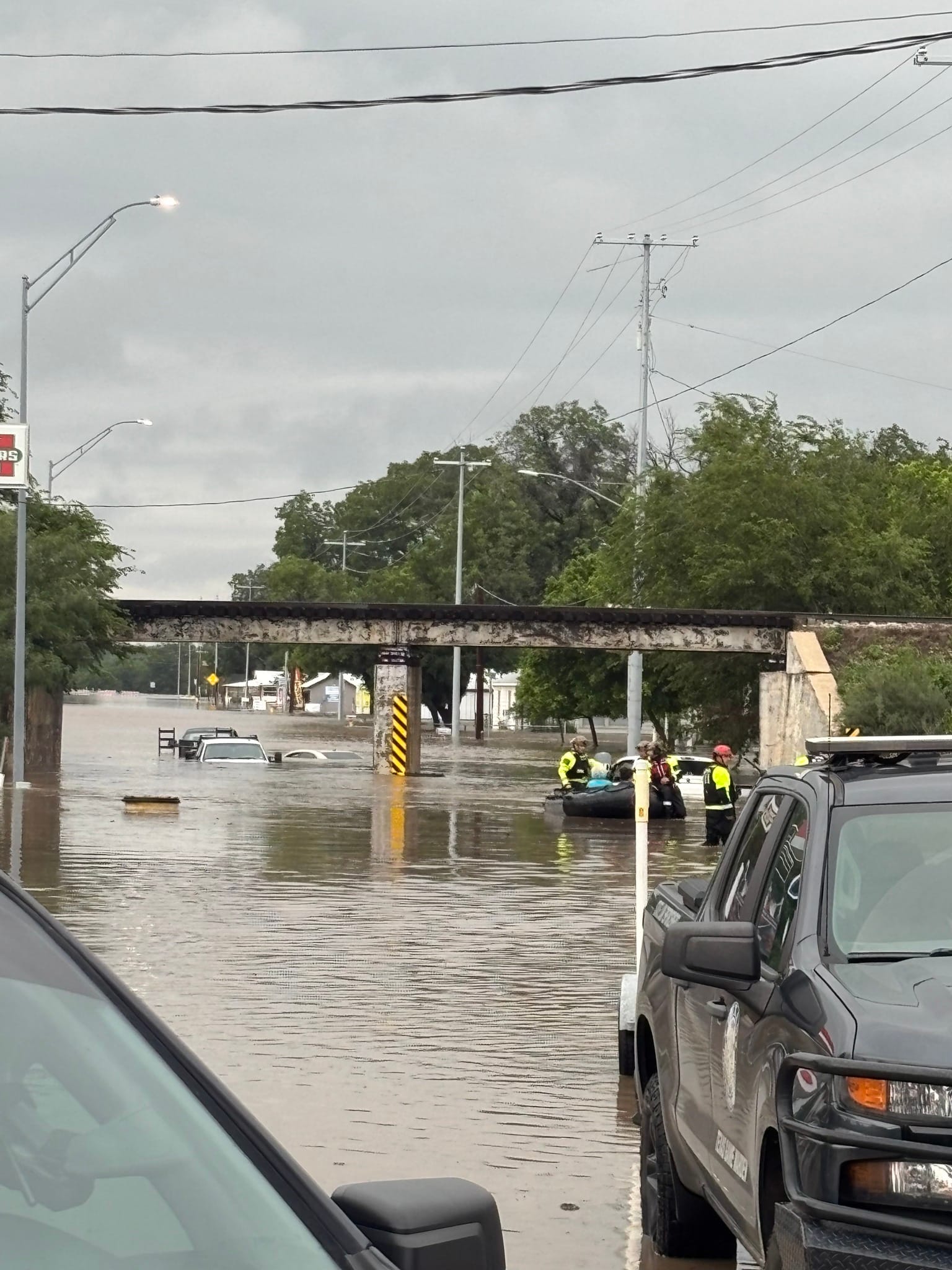
While not the primary cause, Barry still added tropical moisture, along with moisture from the Gulf of Mexico that brought catastrophic flooding to the Texas Hill Country.
One hundred and thirty-five people tragically lost their lives in the devastating Central Texas flash floods, making it one of the deadliest U.S. flash flooding events on record.
Flash Flooding in Kerrville, TX. Courtesy Texas Parks and Wildlife.
Key Takeaway: A storm does not have to be a hurricane to still bring catastrophic rainfall that can result in devasting flooding.
Tropical Storm Chantal was the only landfalling storm in the U.S. this year. Chantal made landfall near Litchfield Beach, South Carolina around 4 AM E.T. on July 6th, 2025. Chantal brought deadly flash flooding to the Carolinas but also multiple tornadoes.
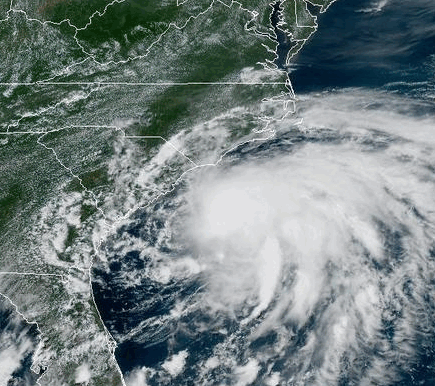

Key Takeaway: Hurricanes are not the only tropical system that can lead to an increase in tornadic activity.
Tropical Storm Dexter was one of many tropical storms this season that formed over open waters and did not impact land. In determining the strength of Dexter, NOAA states:
There were no ship reports of winds of tropical storm force associated with Dexter. However, two NOAA buoys both recorded peak sustained winds of 31 knots near the system on 3 August and were helpful in the analysis of the best track.
Dexter's maximum winds were 58 mph and the minimum pressure dropped to 999 mb.
Tropical Storm Fernand was the final storm to form in August. It also had no major impacts to land and was well forecast by the NHC. The storm system was introduced as an area to be watched, 162 hours before the storm formed well off in the Atlantic and to the east of Bermuda.
Tropical Storm Jerry was the first storm to form in the month of October. While Jerry was forecast to become a hurricane, it was never able to strengthen past a tropical storm. It did however bring heavy rainfall to the Leeward and Virgin Islands. Some locations received half a foot of rain from Jerry's tropical downpours.
Tropical Storm Lorenzo was first monitored as a wave off the coast of Africa on October 9th. It became a tropical storm on the 13th of October. It did not last long, as it made a northern turn into more unfavorable conditions and quickly became a post-tropical low, just two days after forming.
The Record Setting Storm
One storm this season that did not even reach tropical storm status, yet still broke records was Karen.
Subtropical Storm Karen was named late in the evening on Thursday, October 9th. By Friday, October 10th it quickly became a post-tropical low. But one thing that baffled meteorologists was how high up in latitude Karen formed.
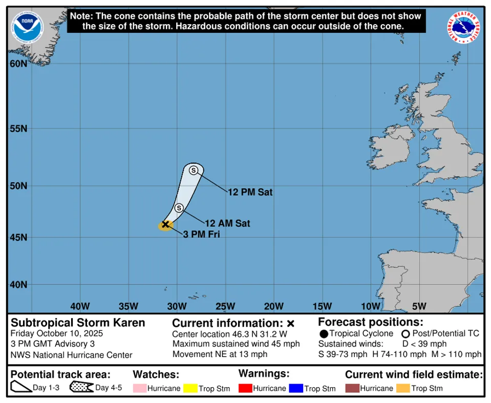
Karen became a named storm at 44.5 degrees North, 33.0 degrees West. That made it the northernmost system in Atlantic history to be issued a tropical or subtropical name by the National Hurricane Center.
What's Next
The National Hurricane Center will produce a Tropical Cyclone Report for each named storm of the 2025 season. This is a comprehensive document analyzing the winds, pressure, impacts to land and other meteorological features for each storm. The reports have begun to be published for this season, and will continue to be updated through the end of 2025 and into early 2026. Hurricane Melissa will likely be one of the final reports conducted. To see the full reports on each storm this season, you can find them on the Tropical Cyclone Report site.
The HailTrace team of meteorologists put together a 2025 hurricane forecast before the start of each hurricane season and track each storm throughout. We will be back with the 2026 Atlantic Hurricane Season forecast in just a few months, so be sure to follow us on HailTrace socials for the latest changes in the forecast!